Friday, September 20, 2013

Bay Circuit Trail Map 9 - Ashland To Sherborn Section Hike

I can summarize this hike in two words,"Sherborn Sucked."

The unmarked trails and inadequate trail guide for this section really got me down. I spent so much time backtracking and looking for the trail in vain that I lost all my enthusiasm for completing the trail. In the final two miles of the 12 mile hike, I decided to abandon my plan to hike the remaining 80+ miles of the trail to Kingston. Now that I've had time to reflect on the hike, I've reconsider my decision, well sort of. I'm in no hurry to go back to the BCT and it's unlikely I will finish the trail before the end of the year.

I should have known I was in for a long hike when I hit a detour in the first quarter mile. Following the detour south on Route 126 in Ashland I turned onto Tri Street. There I encountered another problem. The bridge on Tri Street was was washed out!  Even the detour had a detour so it was back to Route 126 for more road walking. Finally, after more than two miles of pavement I got some dirt under my feet walking under a power line that would take me to Barber Reservation. 


Off-road section in Ashland could not be taken making for a long road walk.


But the detour described in the trail guide was blocked!


I got a sense that I was in for a long day of misfortune.

There wasn't much to Barber Reservation.  A few meadows and some wide dirt paths were all I saw. In fact, the walk along the power line and though the reservation was only a mile long. I took a short break at Barber to have a snack and some water and then took to the road again. What should have been a short half mile road walk turned into a futile search for the trail head on Dexter Drive in Sherborn. I walked up and down the street three times but could not locate the trail that passes through private property and onto farmland that would take me to Brush Hill Reservation.  After a good 30 minutes I decided to continue on the road and find the reservation on my own.

Not a trail but better than the road.


Trail in Barber Reservation

Trail though a grassy meadow in Barber Reservation.

I made a new friend on my road walk from Barber Reservation to Brush Hill Reservation so it wasn't all bad.

After another 1.5 miles of unplanned road walking I located the trail head at Brush Hill Reservation. Unfortunately, the blaze at the trail head was the only one I ever saw. Since the BCT was unmarked here, and there were many intersecting trails, I decided to follow the one that appeared to be the most traveled. It was the logical choice but ended up being an incorrect one. More backtracking, more cursing and inevitably more road walking followed, but I was able to find I my way to Sherborn Town Forest. 


View of the farm I was supposed to hike though but couldn't locate the trail on the opposite side.

Trail in Brush Hill Reservation the led to nowhere.

About two miles of the BCT pass through Sherborn Town Forest. The trail is a mix of wide paths and single-track with some moderate changes in elevation. I was so happy to find the trail was well blazed and easy to follow. That is until I came to a four way intersection one mile into the reservation. I could go left, right or straight ahead but the BCT was not marked here. I looked in all three directions but could not locate a blaze. I looked behind me. Nothing!

 An opening in the trail revealed this building and tower.


I knew the BCT crossed Route 27 to the east so I took the trail on the right and walked east. This time I made the right decision. I continued on this trail for another mile before reaching the roadway.  By now I was pretty frustrated and decided to abandon the rest of the hike and skip the final three miles through Sherborn, missing the best part of the trail through Rocky Narrows Reservation. Instead, I walked 2.5 miles south on Route 27 back to my car that was waiting for me in the Rocky Narrows parking lot. This wasn't the hike I hoped it would be but sometimes stuff happens.

I'll be back......some day. 

Stats:
BCT Maps 9: 12 miles
Surface split: 7m roads, 5m trails
Elevation gain: 672 feet
Highest point: Gibbs Hill.
Start point: Pond Street,Ashland
End point: Rocky Narrows, Sherborn
Other towns: None
Green Spaces: Barber Reservation, Brush Hill Reservation, Sherborn Town Forest 
Hydration: 80 oz water
Fuel: One Cilff Bar
Footwear: Brooks Cascadia 5, Fits socks
Total BCT covered to date: 140 miles
Surface split: 83 trail and dirt road, 50 pavement, 7 paved rail trail
Total elevation gain: 5683+
Highest point: 602 ft
BCT remaining: 62 estimated

Monday, September 9, 2013

Bushwhacking In Rocky Woods

This past Saturday I took an REI Outdoor School map and compass navigation class held at Rocky Woods Reservation in Medfield, MA. It's a skill I've wanted to learn for a few years but never found the time to pursue it. After getting lost in Nobscot Reservation on a Bay Circuit Trail hike a month ago, I thought it was time I finally got around to doing something about it. This class fit the bill.

During the classroom session we learned how to use a compass, read a map, take a bearing, adjust for delineation and other useful information that we would soon put to the test during the field session of the class. This was the part I was waiting for. Time to get dirty!

Our first "assignment" was to bushwhack from a trail junction to a large rock formation known as Whale Rock, a distance of approximately one-third of a mile. Our instructor informed us that beginners typically bushwhack at a pace of one mile per hour so we should be able to complete ours in about twenty minutes. It took me thirty. Oh, and I missed Whale Rock by about 100 feet.

 If you look closely you can see three of my classmates in the brush.

As the name implies, bushwhacking involves moving off trail, often though thick vegetation, over, under and possibly through downed trees and limps, climbing rocks, avoiding holes and an assortment of other obstacles. For those who have never bushwhacked let me tell you it is exhausting work!  

 One of the more open spaces on the bushwhack.

The map I used showing the three bearings I calculated and followed.

The second assignment was to move from Whale Rock to the summit of Mine Hill. This bushwhack was harder than the first because we had to navigate around a pond that was on the direct bearing plotted to Mine Hill. By maintaining a constant compass bearing, changing directions, counting steps, hard effort and a little bit of luck I was able to reach the summit of Mine Hill dead on......and dead f'ing last, well almost.

For the third and final assignment we learned how to intentionally miss our mark when it makes for an easier and faster bushwhack. Our goal was to travel from trail junction 13 to trail junction 15. After marking our bearing and studying the contour lines on the map, we determined a bearing slightly north of our marked route would take us over flatter terrain and still get us to a trail near the intended junction. This last bushwhack turned into a race, sort of, as we were all tramping though the woods with more speed and confidence than earlier in the day.  Great fun!

I hope to practice and become more proficient in this new-found skill over the coming weeks.  Perhaps an orienteering race or two will be in my future.

Monday, August 26, 2013

Bay Circuit Trail Map 8 - Framingham to Ashland Section Hike

I completed my second section hike on the Bay Circuit Trail last week. This one took me from Edmands Road in Framingham to Route 126 in Ashland and covered 15.5 miles of deserted trails, quite back roads and brief spells over busy highways. The total of my two hikes is 25.5 miles. When combined with the 103 miles I ran in 2011, the total miles covered is 128 which is more the half the reported 200 mile length of BCT. This hike also took me south of Interstate 90 which in my mind was the mid-point of the trail. 

After a short walk on Edmands Road the trail turned south into the Sudbury Valley Trustee's Welch Track. The trail was lined with impressive pines as it parallels an equally impressive field stone wall that acts as the boundary line for Callahan State Park. I entered Callahan though a break in the stone wall but could not see any blazes for the BCT. I think I walked too far into the the Welch Track before turning west into Callahan. I used my Mass State Parks phone app to determine my position and map a route back to the Red Tail Trail that was also the BCT route. (Is that considered cheating?) This was the only time I went off trail the entire day. How unusual is that?


Tall pine-lined trail.

Wall at right is boundary line for Callahan State Park.


I crossed Edmands Road and reentered Callahan on the Backpacker's Trail for the climb up to Gibbs Mountain. Initially, I thought I would be climbing to the summit of Gibbs but the BCT merely skirts the flank of the mountain. I was tempted to take the side trail to the summit but decided not considering I had a very long day ahead of me. Instead, I headed down the mountain to the tranquil Beebe Pond. 


Starting the climb up Gibbs Mountain.


Trail on left goes to the summit.


Crossing the dam at Beebe Pond the trail winds uphill again on the Bear Paw Trail.  A large stone chimney stands directly on the trail near Beebe Pond. I have no idea what purpose it serves since there is nothing else nearby. I could not see evidence of an old foundation so I don't think there was ever a building there. I climbed the hill questioning the nearly complete lack of BCT blazing though Callahan. Sure, I was able to find my way relying solely on the written trail description but an occasional confidence blaze would have added to my piece of mind.


 Dam across Beebe Pond.

Peaceful setting


After traveling in a mostly westerly direction in Callahan, the BCT enters Sudbury Reservoir Land and turns south. After navigating my way over a few blow downs and through a short section of overgrown brush, the trail opened up onto a wide dirt road.  I followed this road for nearly two miles making good time on the flat surface. Occasionally, there would be an opening in the woods and I would catch a glimpse of the reservoir to my right. By now I was nearly out of water and becoming dehydrated due to the temperature being in the low 80's. I had no means of purification so all I could do is look at the expanse of reservoir water and keep on walking.


Water, water everywhere, nor any drop to drink.

Smooth flat road on reservoir's edge.


These first five miles were all off road but the next mile ahead of me would be on roads. This worked to my advantage as I was able to obtain a water refill from a man who was cleaning his car in his driveway. I asked if I may fill my water bottles from an outdoor facet but he kindly took them indoors to fill. Armed with 40 oz of liquid gold I moved forward to do battle with Route 30 traffic. Fortunately, it was just a brief skirmish and I soon retreated into the woods via a parking lot next to an abandoned store. 


 This road walk zig-zags the Framingham, Southborough and Ashland boarders.

Sketchy building at trail head near abandoned store. 


My reprieve from the pavement was brief and soon I found myself on an overpass with Route 9 traffic underfoot. From the overpass I descended, and then climbed up a road into and large office park.  The trail description read, "Keep left and in about 100 yards turn right thru landscaping just before office bldg at 175 Crossing Blvd."  Yes, that's all you have to go on at times so it pays to take your time and be observant less you find yourself losing the trail as I have often done. But not today! I ducked through the hedge, down an embankment and onto the Staple's Headquarters Fitness trail.  


 There's a trail in there. Trust me.

Staple's Trail


The Staple's trail was about a mile of winding single-track along the bank of a stream. It was very nice hiking and welcomed break from the sun and heat that was building throughout the day. I once again had to cross a major thoroughfare, this time taking the road over Interstate 90. The noise of the Interstate faded as I walked down a quiet back road that would take me to the Ashland Town Forest.  This time there was no difficulty in finding the trail head.  There was a large, but somewhat faded sign indicating its presence. 


Crossing Interstate 90. A major milestone in my mind. 

This one is for my friend Bill H.  It's not the Ultra Lounge but it's the best I could do.


The two miles through Ashland Town Forest were very well blazed and I had no problems following the BCT despite the many interconnecting trails. Shortly after entering the woods I reached the 10 mile point in the hike. I then had a revelation that I had not seen one other person in the woods all day. Sure, it was a weekday but I suspect it would be pretty much deserted even on a weekend. If you want solitude, take a hike on the Bay Circuit Trail.  


 Trail head on Oregon Road.

I crossed many of these on the hike.


The final four miles of the hike were almost all road walking with a few short off-road sections. I had been feeling good during the hike but started to run out of steam with two miles to go. My feet were getting sore from all the road walking and my legs were feeling heavy. I realized the one hour walks around my neighborhood in no way prepared my for a five hour hike. I pushed on knowing the hike would end at the Market Basket in Ashland. All I had eaten in the past seven hours was a package of peanut butter cracker and I was famished.


 Cool old building in downtown Ashland.

The final footbridge for the day.


Somehow I survived 5 hours and 10 minutes of continuous walking (sounds a lot like my ultra racing) covering 15.5 miles through Framingham, Marlborough, Southborough and Ashland. I had planned to be back on the BCT today and tomorrow for a 40 mile overnight trek but after this hike realized that was too ambitious. I need to do a few more longish day hikes before I can tackle any multi-day adventures.

More pictures and videos from this hike can be found HERE

Stats:
BCT Maps 8: 15 miles
Surface split: 5m roads, 10m trails
Elevation gain: 962 feet
Highest point: Gibbs Hill.
Start point: Intersection of Nixon and Edmands Roads, Framingham
End point: Pond Street,Ashland
Other towns: Sudbury, Southborough
Green Spaces: Callahan State Park, Sudbury Reservoir, Ashland Town Forest 
Hydration: 80 oz water
Fuel: One Cilff Bar
Footwear: Brooks Cascadia 5, Fits socks
Total BCT covered to date: 128 miles
Surface split: 78 trail and dirt road, 43 pavement, 7 paved rail trail
Total elevation gain: 5011+
Highest point: 602 ft
BCT remaining: 72 estimated

Sunday, July 21, 2013

Back To The Bay Circuit Trail - Weyland to Framingham Section Hike Report

After a two year absence I returned to the Bay Circuit Trail, not as a runner but as a hiker. In 2011, I attempted to run the 200 mile BCT from Newbury to Kingston MA. Five runs and 100 +  miles later I abandoned the project due to severe knee pain caused by ITBF syndrome. Now, I am hoping to complete the final 100 miles in a series of weekend section hikes. Only time will tell if I am successful.  

All week long the weather had be oppressively hot and humid and this day was no exception. Dressed in a long-sleeved shirt and long pants to keep the ticks at bay would only make the weather conditions more miserable, but I'd rather be overheating than playing host to some blood-sucking tick. I was not looking forward to walking the first five miles of this section as it would be a long, hot road walk. The BCT Alliance has plans to move this section off-road onto an abandoned railroad line but until that happens you have to make the long road walk on Pelham Island, Landham, and Boston Post Roads if you want to be an "official" end-to-ender of the BCT.


A lonely, quiet stretch of road before I reached the mayhem of Route 20.

My hike began where it ended two years ago, on the bridge spanning the Sudbury River in Weyland MA. After a half mile road walk the trail took a turn onto the vast meadows of Heard Farmonce inhabited by the Indians of the Nipmucks. Walking deep into the meadow I realized I had missed a turn so I had to back-track to find the turn that would take me back to Pelham Island Road. Less than one mile into a ten mile hike and I had already lost the trail!  It wouldn't be the last time.

View of the Sudbury River.

The meadows of Heard Farm.

Getting lost is something I do well.

It didn't take me long to find the missed turn and I was soon back on the hot pavement. I didn't mind it all that much since I had a nice view of Heard Pond to my left and the thick woods of the Great Meadow National Wildlife Refuse to my right. I passed this section and the traffic noise began to build. Soon I would be faced with a blistering hot two mile walk along Route 20 in Sudbury. Once on Route 20 (aka Boston Post Road) there was plenty of noisy traffic but little shade and I questioned my decision to do the hike on such a hot and humid day. Once I entered the Weissblatt Conservation, the road noise was slowly replaced with solitary footsteps as I walked deeper into the woods.  

Heard Pond

Entrance to Great Meadows

The road walk wasn't all bad.  Nice view of the wetlands along Landham Road.

Sometimes I complain too much.

The second five miles were the exact opposite of the first with quiet forests, single-track trails, hilly terrain, rocky outcrops and hordes of mosquitoes awaiting me. The trail climbing up to Tippling Rock looked very similar to one of my favorite places, the Ridge Trail in Breakheart Reservation. I really miss my runs there with my friend Mary. While making the climb I was also reminded how unfit I am as I was breathing heavily on what was a modest climb at best. Upon reaching the summit I was rewarded with a nice view of The Blue Hill is the far distance. 

Wiessblatt Conservation was a pleasant sight after a long road walk.

The familiar white blaze of the BCT.

This looks much like the Ridge Trail In Breakheart.

Tippling Rock

Nice view from the ridge.


I lost the BCT soon after passing Tippling Rock. I realized had missed the turn only after I had descended all the way to the bottom of the hill.  Being too lazy to make the trek back up, I decided to take an alternate route with the hope of picking up the BCT somewhere in the Nobscott Boy Scout Reservation. In retrospect, I wish I had not done this since it resulted in missing Nobscott Hill, which at 602 feet is the highest point on the BCT. Nobscott Hill commands a 360 degree view that includes The Blue Hills, Lower Kearsarge, Mount Monadnock and Mount Wachusett. I did get to wander around the Boy Scout Reservation which was uninhabited at the time and a little creepy, but fun. There were many interconnecting trails in the reservation (for which I didn't have a map) so by trial and error, and a little bit of compass reading I managed to find the BCT again.

Steep descent from Tippling Rock

Pavilion in the Boy Scout Reservation

One of the many unoccupied cabins on the Boy Scout Reservation.

Lost and Found 


Leaving Nobscott, I took a side trail off the BCT to check out Ford's Folly.  Ford's Folly is a 60 ft high, 900 ft long stone and concrete dam built by Henry Ford (more like financed by) using traditional methods of manpower and oxen. Ford wanted to store water for his nearby grist mill.  Unfortunately, the dam failed to hold any significant water, creating only wetlands on the upstream side. It was theorized that the water flow was to meager and the soil to porous to hold enough water. This is how the dam became known as Ford's Folly. It's an impressive feat of engineering, although useless.

Lush fern-lined trail approaching the Ford's Folly side trail.

Two tenths of a mile off the BCT is a dam called Ford's Folly.

.You can walk across the top of the dam.

Down-stream side of the dam.

Ford's Folly

The final two miles of the the hike were through Sudbury Valley Trustee properties. Most of the trails were picturesque and well maintained but there was one section that appeared to get little use and was unmaintained and very overgrown. The trail was difficult to distinguish through the undergrowth but because it was well blazed I was able to stay on trail the entire time. I did start to head in the wrong directions after climbing Henry's Hill but I soon realized my error and was back on the right track without losing too much time. By then, I had been without water for over an hour and wanted to finish as quickly as possible.

Buggy Wittenborg Woods

This stone wall went on for as far I as could see.

Old farming equipment deep in the woods.

Yes, this is the trail,


After cresting Henry's Hill it was a short downhill walk to Edmands Road where I called a cab to take me back to Weyland where I had parked my car. Paying $27 for a ride put a damper on my post-hike euphoria but I was happy to be back on the BCT inching my way closer to it's southern terminus in Kingston. As much I as enjoyed the hike it didn't have the same feel as when I was running the trail back in 2011. I guess I'll always be a runner at heart and being a hiker is something I'll have to learn to accept.  

In time, I'm sure I will.

Many more photos and videos of this hike can be viewed HERE.

Stats:
BCT Maps 7 & 8: 10 miles
Surface split: 5m roads, 5m trails
Elevation gain: N/A, GPS failed
Highest point: Tippling Rock, 426 feet, should have been Nobscott Hill but I missed the trail to it.
Start point: Sudbury River, Weyland
End point: Intersection of Nixon and Edmands Roads, Framingham
Other towns: Sudbury
Green Spaces: Heard Farm, Weissblatt Conservation Land, Nobscott Boy Scout Reservation, Wittenborg Woods, Sudbury Valley Trustees Gross Tract
Hydration: 40 oz water
Fuel: One Cilff Bar
Footwear: Brooks Cascadia 5, Fits socks
Total BCT covered to date: 113 miles
Surface split: 68 trail and dirt road, 38 pavement, 7 paved rail trail
Total elevation gain: 4049+
Highest point: 426 feet (602 ft)
BCT remaining: 87 estimated


Monday, July 15, 2013

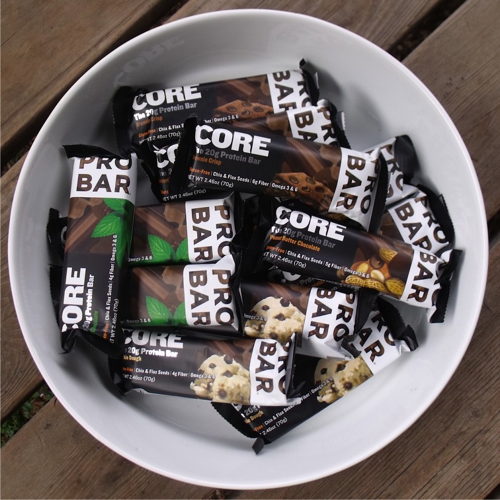
Probar Core Protein Bar Review

I've been a fan of Probar products for many years. I recently tried their new Core bar and was not disappointed.  Probar Core are vegan and diary free, packed with 20 grams of protein from soy isolate, boasts chia and flax seeds for hydration and contain Omega 3 & 6 making it a great post-workout recovery meal.  It's also gluten-free, but unlike many other gluten-free products I've tried it doesn't taste like cardboard. Mint Chocolate is my favorite flavor but Probar Core also come in Brownie Crisp, Cookie Dough and Peanut Butter Chocolate.  My only complaint is that all the the bars have a thin chocolate coating.  It's not that I dislike chocolate, but in warmer weather the chocolate melts into a gooey mess.  If you're looking for a easy and tasty way to add some extra protein to your diet, Probar Core may be the bar for you.

Disclaimer: Probar provided Breakheart Trail Running with sample of Probar Core Bars for tasting and review.

Related Posts Plugin for WordPress, Blogger...