On a brisk and bright October morning, Bill, Tony and I began our final ride on the Bay Circuit Trail. Only 21 miles of the 206-mile journey remained before we would reach the southern terminus at Bay Farm in Duxbury. As with previous rides, this one did not go smoothly and we encountered overgrown trail, numerous blowdowns and a road closure due to bridge construction. Still, we were not deterred and reached the Atlantic Ocean at 11:32 on the moring of October 12, 2024.
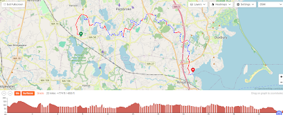
Route overview - Red is paved, blue is unpaved.
Bill, waiting up for me, again!
Swans on pond in Tubbs Meadow.
Southern terminus of the Bay Circuit Trail. It took a while, but I finally got there.
View of Kingston Bay from the Southern terminus.
BCT end-to-end victory pose!
Ride Summary:
Day 10 - 20.8 miles, 205.8 cumulative.
Paved - 14.0 miles, 115.8 cumulative.
Paved - 14.0 miles, 115.8 cumulative.
Unpaved - 6.8 miles, 90.0 cumulative.
Elevation gain - 1,362 feet, 12,718 cumulative.
Max grade - 16.2%
High point - Bonney Hill (High Street), Hanson 134 feet
Towns traversed - Hanson, Pembroke and Duxbury
Green spaces visited - Tubbs Meadow, Pembroke Town Forest, Trout Farm Conservation Area, Duxbury Bogs and Bay Farm


